Stories
- Article
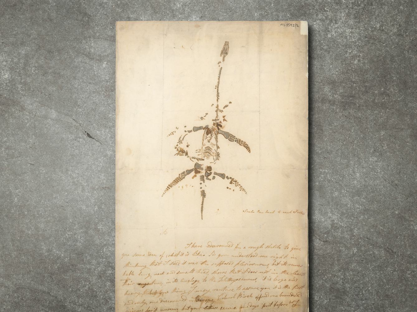
Would you like to buy a dinosaur?
Two remarkable letters and a drawing of a plesiosaur by Mary Anning offer a tantalising portal into the exciting world of fossil hunting and discovery of the 1800s.
- Article
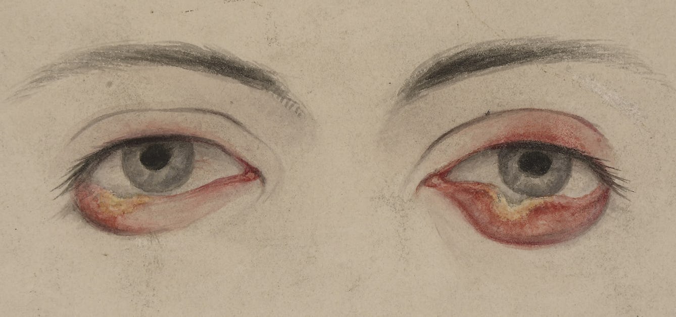
The prostitute whose pox inspired feminists
Fitzrovia, 1875. A woman recorded only as A.G. enters hospital and is diagnosed with syphilis.
- Article
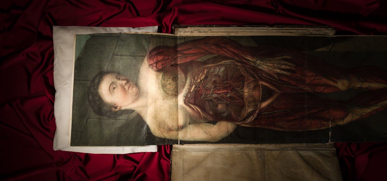
Printing the body
The 18th century saw multiple technical developments in both printing and medicine. Colourful collaborations ensued – to the benefit of growing ranks of medical students.

- Article
Louis Wain’s cryptic cats
Once famous for his quirky cat illustrations, today Louis Wain is often portrayed as a ‘psychotic’ artist whose illness can be mapped out through his drawings. Here Bryony Benge-Abbott takes a more rounded view.
![Carthamus tinctorius L. Asteraceae. Safe Flower, False Saffron - Distribution: W. Asia. Dioscorides (in Beck, 2003) notes the seeds as a purgative, but also advises it made up with 30 figs, which must have helped. Gerard (1640) calls it Atractylis flore luteo the yellow distaffe thistle. and follows Dioscorides in its uses, but does get the reader confused with Cnicus benedictus, calling both plants 'wild bastard saffron'. Culpeper makes no mention of it in his early works, but later (1826) have the following: ‘Wild Saffon, or Saf-flower ... accounted a pretty strong cathartic [causing diarrhoea and vomiting], evacuating tough viscid phlegm, both upwards and downwards, and by that means is said to clear the lungs, and help the phthisic [now equated with tuberculosis]. It is likewise serviceable against the jaundice](https://iiif.wellcomecollection.org/image/B0008960/full/282%2C/0/default.jpg)

![[A new booke entyteled the regiment of lyfe: with a syngular Treatise of the pestilece].](https://iiif.wellcomecollection.org/image/L0037382/full/282%2C/0/default.jpg)
![The theory of the earth : containing an account of the original of the earth, and of all the general changes which it hath already undergone, or is to undergo till the consummation of all things. The two fisrt [sic] books, concerning the deluge, and concerning paradise.](https://iiif.wellcomecollection.org/image/L0014827/full/282%2C/0/default.jpg)
![Ḥeleḳ riʼshon [shelishi] mispar ha-ʻolamot o maʻaśeh ṭoviyah / [Tobias Cohen].](https://iiif.wellcomecollection.org/image/L0015958/full/320%2C/0/default.jpg)
![Ḥeleḳ riʼshon [shelishi] mispar ha-ʻolamot o maʻaśeh ṭoviyah / [Tobias Cohen].](https://iiif.wellcomecollection.org/image/L0015960/full/282%2C/0/default.jpg)
![Ḥeleḳ riʼshon [shelishi] mispar ha-ʻolamot o maʻaśeh ṭoviyah / [Tobias Cohen].](https://iiif.wellcomecollection.org/image/L0000097/full/282%2C/0/default.jpg)
![Ḥeleḳ riʼshon [shelishi] mispar ha-ʻolamot o maʻaśeh ṭoviyah / [Tobias Cohen].](https://iiif.wellcomecollection.org/image/L0024382/full/600%2C/0/default.jpg)
![Ḥeleḳ riʼshon [shelishi] mispar ha-ʻolamot o maʻaśeh ṭoviyah / [Tobias Cohen].](https://iiif.wellcomecollection.org/image/L0015959/full/282%2C/0/default.jpg)
Catalogue
- Books
- Online
The large English atlas: or, a new set of maps of all the counties in England and Wales, drawn from the several surveys which have been hitherto published. With three general Maps of England, Scotland, and Ireland, From the latest and best Authorities. 1 England 2 Scotland 3 Ireland 4 Bedfordshire 5 Berkshire 6 Buckinghamshire 7 Cambridgeshire 8 Cheshire 9 Cornwall 10 Derbyshire 11 Devonshire 12 Dorsetshire 13 Durham 14 Essex 15 Gloucestershire and Monmouthshire 16 Hampshire 17 Hertfordshire 18 Herefordshire 19 Huntingdonshire 20 Kent 21 Lancashire 22 Leicestershire and Rutlandshire 23 Lincolnshire 24 Middlesex 25 Norfolk 26 Northamptonshire 27 Northumberland 28 Nottinghamshire 29 Oxfordshire 30 Shropshire 31 Somersetshire 32 Staffordshire 33 Suffolk 34 Surrey 35 Sussex 36 Warwickshire 37 Westmoreland and Cumberland 38 Wiltshire 39 Worcestershire 40 Yorkshire 41 East Riding of ditto 42 North Riding of ditto 43 West Riding of ditto 44 Cardiganshire and Pembrokeshire 45 Carmarthenshire and Glamorganshire 46 Radnorshire and Brecknockshire 47 North Wales, Containing in one Map the Counties of Carnarvon Denbigh Flint Merioneth Montgomery and The Island of Anglesey laid down on a large scale, And containing all the Cities, Towns, Villages, and Churches, whether Rectories or Vicarages, Chapels, many Noblemen's and Gentlemen's Seats, &c. &c. Each Map is Illustrated With a General Description of the County, its Cities, Borough and Market Towns, the Number of Members returned to Parliament, of Parishes, Houses, Acres of Land, &c. And Historical Extracts relative to the Trade, Manufactures, and Government of the Cities and Principal Towns, and the present State of their Inhabitants, &c. By Emanuel Bowen, Geographer to His Majesty, Thomas Kitchen, and others.
Bowen, Emanuel, 1693 or 1694-1767.Date: [1777?]- Books
- Online
Jefferys's itinerary; or travellers companion, through England, Wales, and part of Scotland, containing all the direct and principal cross roads; with The Addition of every New Road, carefully collected from all the actual Surveys hitherto published. Improved with many thousand names of places more than are in any similar publication. To which are added copious indexes to all the roads and places mentioned in the work, with their exact Distance from London.
Jefferys, Thomas, -1771.Date: MDCCLXXV. [1775]- Books
- Online
A New atlas of France: Comprising maps of the eighty-three departments, beautifully engraved and coloured, each department being divided into its several districts and cantons. also, two general maps of France, exhibiting that country both in its former and present divisions. To which is added, a general alphabetical index of all the cities, towns and villages, with the districts and departments to which they belong.
Date: 1724- Books
- Online
By desire of several noblemen, gentlemen, and others, John Andrews and A. Dury, propose publishing by subscription, a topographical map of the county of Kent, in twenty-five sheets ...
Andrews, John, 1736-1809.Date: 1765]- Books
- Online
Ellis's English atlas: or, A compleat chorography of England and Wales: In fifty-four maps. Containing more particulars than any other collection of the same kind. The whole calculated for the use of travellers, academies, and of all those who desire to improve in the knowledge of their country. From the latest surveys of the several counties; with the addition of four maps, viz. of the rivers of England and Wales; of twenty-five miles of the country round London; of the island of Jersey; and of Guernsey, Sark, Alderney, and Burhou. Engraved by, and under the direction of, J. Ellis.
Ellis, J. (John), active 1750-1800.Date: MDCCLXVI. [1766]