246 results
- Pictures
Sailing ships at sea; a man dreaming; other subjects. Coloured magic lantern slides.
Date: [between 1800 and 1899?]Reference: 748222i- Pictures
Sailing ships and a steamship at sea; Dunloe Castle, Killarney. Coloured magic lantern slides.
Date: [between 1800 and 1899?]Reference: 748274i
- Pictures
- Online
Sailing ships and rowing boats at Alexandria, Egypt. Coloured lithograph by Louis Haghe after David Roberts, 1849.
Roberts, David, 1796-1864.Date: [1849]Reference: 33609iPart of: Egypt and Nubia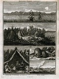
- Pictures
- Online
Sailing ships at sea, turnip-like plants found in northern Russia and the Samoyed people with their tents and boats, in separate plates. Engraving after C. de Bruin, 1701.
Bruyn, Cornelis de, 1652-1727.Date: [1718]Reference: 20216i- Pictures
A magician's cave; sailing ships at sea; kaleidoscopes. Coloured magic lantern slides.
Date: [between 1800 and 1899]Reference: 748272i- Books
- Online
Signals for the Royal Navy and ships under convoy. Sailing & fighting instructions. Articles of warr regulations &c. ... Given by ye Lords of ye Admiralty, to flag & other officers, ... beautifully engrav'd & colour'd, for J. Millan ...
Great Britain. Royal Navy.Date: [1748]- Pictures
A magician's cave; sailing ships and steamship at sea; kaleidoscope; children. Coloured magic lantern slides.
Date: [between 1800 and 1899?]Reference: 748273i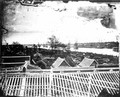
- Digital Images
- Online
View of the Manam river, Bangkok, Siam, with sailing ships anchored
John Thomson
- Pictures
- Online
Civil engineering: the Wearmouth Iron Bridge at Sunderland, with ships sailing beneath, and details (above). Coloured engraving by J. Pass, 1799.
Date: 1799Reference: 44411i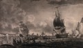
- Pictures
- Online
Men are fishing for whale in small boats with harpoons; larger sailing ships are in the distance. Aquatint.
Reference: 37600i
- Pictures
- Online
A line of hot-air balloons loaded with boxes advertise "A. Stevens" as they travel over a line of sailing ships. Wood engraving.
Reference: 36415i
- Pictures
- Online
Scenery to be used in a toy theatre: ships sailing on the sea near a coast, with a wooden building and palm trees on it. Lithograph.
Date: 17 Decr. 1823Reference: 33555iPart of: Cortez, or, Conquest of Mexico- Books
- Online
The universal navigator; or, A Comprehensive Treatise of navigation; containing, I. The most useful Problems in Geometry, Measuring of Plank, Timber Bales, Boxes, and Tunnage of Ships. II. Trigonometry with its application to the taking of Heights and Distances, accessible and inaccessible. III. Navigation, (viz.) Plain Sailing, Traverse Sailing, Mercator, Middle Latitude, and Parallel Sailing, with all the several examples wrought Geometrically, Trignometrically, by Logarithms, Arithmetically, by Natural Sines and Tangents, Instrumentally, and by Tables of Latitude and Departure. To which is annexed a curious Collection of Questions to exercise all the above kind of Sailing, with a large and correct Table of Difference of Latitude and Departure, and Meridional parts. Also a Table of Latitude and Longitude of Places. IV. Great Circle Sailing, with a curious Collection of Questions applied thereto, several of which have never appeared in any Treatise of Navigation extant. Oblique Sailing, Turning to Windward, Sailing in Currents, with a Collection of Questions both curious, useful, and entertaining, to exercise the same. V. The Gregorian Calender, shewing the best method of finding the Prime-Epact, Moon's age, time of High Water, with a large Tide-Table, alphabetically digested, the manner of working Observations, the best Method of finding the variation of the Compass. To keep a Sea Journal in the best approved method, both in Merchant's Ships and the Royal Navy, also to correct the Dead Reckoning by a good Observation, by the easiest and best approved Method, illustrated with full, proper, and practical examples of the same, together with all useful Astronomical Tables, viz. the Sun's Declination, a Table of Logarithms, of Nat. and Artificial Sines and Tangents, with a curious collection of Astronomical Problems useful in taking Observations at any time of the Day, or by two Observations, and having the time between them, without regarding the Hour; several of them have not appeared in any other Author. With an appendix, shewing how to work all the cases in navigation by the pen arithmetically, without Books, Tables, or Instruments. By William Chambers, Teacher of the Mathematics.
Chambers, William, teacher of the mathematics.Date: MDCCLXXIV. [1774]
- Pictures
- Online
A large iceberg with a ship sailing past it. Coloured engraving by or after E. Weedon.
Weedon, Edwin, 1819-1873.Date: 1800-1899Reference: 46884i- Books
- Online
The theory of the working of ships, applied to practice. Containing the principles and rules for sailing with the greatest advantage possible. By Mons. Pitot, Of the Royal Academy of Sciences at Paris. Translated from the French, by Edmund Stone, F. R. S.
Pitot, Henri, 1695-1771.Date: M.DCC.XLIII. [1743]
- Archives and manuscripts
- Online
M0004429: Drawing of galleys and ships from the Ninevah expedition, 1845
Date: 13 November 1935Reference: WT/D/1/20/1/35/52Part of: Wellcome Trust Corporate Archive- Pictures
A sailing ship beached on a shore and being worked on by a mechanical excavator. Watercolour by N. Goullet, 1955.
Goullet, Nancy, active approximately 1954-1957.Date: 28/9/55 [28 September 1955]Reference: 2969683iPart of: Adamson Collection- Books
- Online
A Register of ships, employed in the service of the Hon. United East India company, From the year 1780 to the present period, specifying the tonnage, number of voyages, stations, managing owners, commanders, principal officers, surgeons, and pursers; with the dates of their sailing and arrival: also, a comparative view of the tonnage, employed in each year, shewing the number of ships destined to each settlement. To which is added, an appendix, containing many particulars, interesting to those concerned in the East India trade.
Date: 1800- Ephemera
Lifebuoy Royal Disinfectant Soap : for saving life / [Lever Brothers Ltd.].
Lever Brothers Ltd.Date: [between 1890 and 1899?]- Books
- Online
The oriental navigator; or, new directions for sailing to and from the East Indies. Also for the use of the country ships, trading in the Indian and China Seas; to New Holland, &c. &c. Collected from the manuscripts, journals, memoirs, and observations, of the most experienced officers ... Being a companion to the East India pilot, ... by the late Mr. Robert Sayer; ...
Date: 1794 [1797]- Books
- Online
Sailing directions for the island of Jamaica and St. Domingue, or Hispaniola, and the windward passages, to be used with the charts and plans that are published from surveys and observations, Made by Order of Philip Affleck, Esq. Rear Admiral of the White, and Commander in Chief of his Majesty's Ships and Vessels at Jamaica, &c. &c. In part of the Years 1789, 1790, 1791, and part of 1792. By John Leard, and Assistants.
Leard, John, marine surveyor.Date: [1792]- Books
- Online
The new seaman's guide, and coaster's companion, Containing complete sailing directions for ships, both outward and homeward bound, through the River Thames, and all its entrances, the British and Bristol Channels, on both coasts, including all the harbours; the coast of Wales; West Coasts of England and Scotland; the South coasts of Ireland; and the islands of Man, Scilly, Guernsey, Jersey, Alderney, &c. Also the East Coast of Great Britain, with the Orkney, Shetland, and Western Islands; the Coasts of Flanders, Holland, and Germany; the North Sea, Cattegat, Sound, Baltic, gulf of Finland, and northern navigation to the White Sea. And all the useful tables, viz. tables of the magnetic courses, and distances from place to place, for all the Coasts of Europe, and many of Africa and Asia: with the variations. A table of the distances by water, in miles, from London to the principal ports in Great Britain, Ireland, part of France, Flanders, Holland, Norway, Sweden, Denmark, throughout the Baltic and the Mediterrean. Copious tables of latitudes and longitudes, from the best and latest observations: and improved and corrected tide tables; to which are subjoined, easy methods of sinding the Epagt, the moon's age, and the day of new moon. A new and correct edition: improved and augmented by many important additions and observations from new surveys. By John Diston, M. Downie, master in the Royal Navy, and Alexander Ingram,teacher of Navigation and mathematics in Leith, and author of the newly much improved and corrected edition of Simson's Euclid; as also of the principles of geography, and of the corrected and enlarged edition of Hutton's arithmetic and key.
Diston, John.Date: 1800- Pictures
Anamur, Turkey: ships near the coast. Steel engraving by J. Tingle, 1841, after W.H. Bartlett.
Bartlett, W. H. (William Henry), 1809-1854.Date: 1841Reference: 2124762i
- Pictures
- Online
Astronomy: a sailing ship at the North Cape, Norway, sailing under the midnight sun. Engraving, 1825.
Date: 1 January 1825Reference: 46621i- Books
- Online
An account of the fish-pool: consisting of a description of the vessel so call'd, lately invented and built for the importation of fish alive, and in good Health, from Parts however distant. A Proof of the Imperfection of the Well-Boat hitherto used in the Fishing Trade. The true Reasons why Ships become stiff or crank in Sailing; with other Improvements, very useful to all Persons concern'd in Trade and Navigation. Likewise, a description of the carriage intended for the conveyance of fish by land, in the same good Condition as in the Fish-Pool by Sea. By Sir Richard Steele, and Mr. Joseph Gillmore, Mathematician.
Steele, Richard, Sir, 1672-1729.Date: 1718