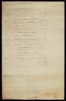
The drawing and document comprise the following: 1. ‘Plan of Retreat Ground’ [1794] This small sketch is the earliest map of the Retreat estate. On the back it is annotated ‘Land bought for the Retreat’. It gives acreages of the closes and fields. It marks the buildings but it is probable that these may be notional, in accordance with Peter Atkinson’s drawings of the shape of the prospective building. The total acreage of the estate is given as 11 acres, 0 roods and 37 perches, the acreage referred to in the Directors’ Minutes of 4 April 1794, after some of the outlying parts of the estate had been sold off. 2. Survey of Retreat Ground [1794-5] This is a list of the acreages of the different closes, garden and grounds which made up the estate. The total is 11 acres, 0 roods and 10 perches. This is 27 perches less than the plan above. In the Directors’ Minutes of 25 December 1794 it is noted that a small piece of land of 27 perches had just been sold off; this survey can thus be dated to very late 1794 or 1795.