146 results

- Pictures
Noch Slak, wife of Captain Jack of Kisbyyoks (Kispiox), British Columbia. Pastel by W. Langdon Kihn, 1924.
Kihn, W. Langdon.Date: 1924Reference: 45894i- Books
- Online
The dangerous voyage of Capt. Thomas James, in his intended discovery of a north west passage into the South Sea: Wherein The Miseries indured, both Going, Wintering and Returning, and the Rarities observ'd Philosophical, Mathematical and Natural are related in this Journal of it, publish'd by the Special Command of King Charles I. To which is added, a map for sailing in those seas: also divers tables of the Author's of the Variation of the Compass, &c. With an appendix concerning the longitude, by Master Gellibrand, Astronomy Reader at Gresham College.
James, Thomas, 1593?-1635?.Date: MDCCXL. [1740]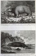
- Pictures
- Online
America: above, a white bear on an ice floe; below, a sea otter. Etching by W. Grainger.
Reference: 42092i
- Books
- Online
Historical view of the progress of discovery on the more northern coasts of America from the earliest period to the present time / by Patrick Fraser Tytler ; with descriptive sketches of the natural history of the North American regions. By James Wilson. To which is added an appendix. Containing remarks on a late memoir of Sebastian Cabot, with a vindication of Richard Hakluyt ; illustrated by a map and nine engravings by Jackson.
Tytler, Patrick Fraser, 1791-1849.Date: 1832- Books
- Online
The english pilot. The fourth book. Describing the West-India navigation from Hudson's-Bay to the River Amazones. Particularly Delineating The Sea-Coasts, Capes, Head-Lands, Rivers, Bays, Roads, Havens, Harbours, Streights, Rocks, Sands, Shoals, Banks, Depths of Water, and Anchorage. With All the Islands therein, as Jamaica, Cuba, Hispaniola, Barbadoes Bermudoes, Porto Rico, and the rest of the Carribe and Bahama Islands. Also A New Description of Newfound-Land, New-England, New-York, East and West New-Jerzey, Dellewar-Bay, Virginia, Mary-Land, and Carrolina, &c. Shewing The Courses and Distances from one Place to another, the Ebbing and Flowing of the Sea, the Setting of the Tides and Currents, &c. With many other things Necessary to be known in Navigation. The whole being very much enlarged and corrected, with the additions of several new charts and descriptions, not before publish'd. By the information of divers able navigators of our own and other nations.
Date: 1706- Books
- Online
The english pilot, describing the sea-coasts, capes, headlands, streights, soundings, Sands, Shoals, Rocks and Dangers. The bays, roads, harbours, and ports in the oriental navigation, Shewing the Property and Nature of the Winds and Monsoons in those Seas; with the Courses and Distances from one Place to another: The Setting of the Tides and Currents; The Ebbing and Flowing of the Sea. Also, A New table of Variations; and a Correct table of Longitudes and Latitudes; With many other things necessary to be known. Containing several large Draughts of Ports, Islands, and Descriptions; collected from the Practice and Experience of divers able and expert navigators of our Own and Foreign Nations. Divided into three parts. The first, Shewing The Nature and Properties of the Winds and Monsoons in the Navigation from England, to the East-Indies, and the whole oriental ocean, and thereby how to shape a Course from one Port to another, according to the Time of the Year in those Seas. The second, Containing Necessary instructions for Sailing between England, and the East-Indies, in the Spring and Autumn. The third, Describing The Sea-Coasts, Capes, Headlands, Streights, Soundings, Sands, Shoals, Rocks and Dangers. The Islands, Bays, Roads, Harbours and Ports, from Cape Bona-Esperance, to all Parts of the oriental ocean, being very much Corrected and Augmented with several Additions, not before Publish'd.
Date: M,DCC,LV. [1755]- Books
- Online
The english pilot. Describing the West-India navigation, from Hudson's Bay to the River Amazones. Particularly Delineating The Coasts, Capes, Headlands, Rivers, Bays, Roads, Havens, Harbours, Streights, Rocks, Sands, Shoals, Banks, Depths of Water, and Anchorage, with all the Islands therein; as Jamaica, Cuba, Hispaniola, Barbadoes, Antigua, Bermudas, Porto Rico, and the rest of the Caribbee and Bahama Islands. Also A new Description of Newfoundland, New England, New York, East and West New Jersey, Dellawar Bay, Virginia, Maryland, Carolina, &c. Shewing The Courses and Distances from one Place to another; the Ebbing and Flowing of the Sea, the Setting of the Tides and Currents, &c. With many other Things necessary to be known in Navigation. The whole being much enlarged and corrected, with the additions of several new charts and descriptions. By the information of divers able navigators of our own and other nations.
Date: M,DCC,LXXXIX. [1789]- Books
- Online
The English pilot. The fourth book, describing West-India navigation, from Hudson's-Bay to the river Amazones. Particularly delineating the sea-coasts, capes, headlands, rivers, bays, roads, havens, harbours, straits, rocks, sands, shoals, banks, depths, of water and anchorage, with all the islands therein, as Jamaica, Cuba, Hispaniola, Barbadoes, Antigua, Bermudas, Porto-Rico, and the rest of the Caribbee and Bahama Islands. Also a new description of Newfoundland, New-England, New-York, East and West New-Jersey, Dellawar-Bay, Virginia, Maryland, and Carolina, &c. Shewing the courses and distances from one place to another, the ebbing and flowing of the sea, the setting of the tides and currents, &c. with many other things necessary to be known in navigation. The whole being much enlarged and corrected, with the additions of several new charts and descriptions. By the information of divers able navigators of our own and other nations.
Date: M,DCC,LXI. [1761]- Books
- Online
The English pilot. The fourth book. Describing the West India navigation, from Hudson's-Bay to the river Amazones. Particularly delineating the sea-coasts, capes, headlands, rivers, bays, roads, havens, harbours, straits, rocks, sands, shoals, banks, depths of water and anchorage, with all the islands therein, as Jamaica, Cuba, Hispaniola, Barbadoes, Antigua, Bermudas, Porto-Rico, and the rest of the carribbee and Bahama Islands. Also, a new description of Newfoundland, New-England, New-York, East and West New-Jersey, Dellawar-Bay, Virginia, Maryland, and Carolina, &c. Shewing the courses and distances form one place to another, the ebbing and flowing of the sea, the setting of the tides and currents, &c. with many other things necessary to be known in navigation. The whole being much enlarged and corrected, with the additions of several new charts and descriptions. By the information of divers able navigators of our own and other nations.
Date: M.DCC,LXV. [1765]- Books
- Online
The English pilot. The fourth book. Describing the West-India navigation, from Hudson's-Bay to the River Amazones. Particularly delineating the sea-coasts, capes, head-lands, rivers, bays, roads, havens, harbours, straits, rocks, sands, shoals, banks, depths of water and anchorage, with all the islands therein, as Jamaica, Cuba, Hispaniola, Barbadoes, Antigua, Bemudas, Porto-Rico, and the rest of the Caribbee and Bahama Islands. Also a new description of Newfoundland, New-England, New-York, East and West New-Jersey, Dellavar-Bay, Virginia, Maryland, and Carolina, &c. Shewing the courses and distances from one place to another, the ebbing and flowing of the sea, the setting of the tides and currents, &c. With many other things necessary to be known in navigation. The whole being much enlarged and corrected, with the additions of several new charts and descriptions. By the information of divers able navigators of our own and other nations.
Date: M,DCC,LX. [1760]- Books
- Online
The english pilot. The fourth book. Describing the West-India navigation, from Hudson's-Bay to the River Amazones. Particularly Delineating The Sea-Coasts, Capes, Head-Lands, Rivers, Bays, Roads, Havens, Harbours, Straits, Rocks, Sands, Shoals, Banks, Depths of Water, and Anchorage With all the Islands therein, as Jamaica, Cuba, Hispaniola, Barbados, Antigua, Bermudas, Porto-Rico, and the rest of the Caribbee and Bahama Islands Also A New Description of Newsound-Land, New-England, New-York, East and West New Jersey, Dellevar-Bay, Virginia, Mary Land and Carolina, &c. Shewing The Courses and Distances from one Place to another, the Ebbing and Flowing of the Sea, the Setting of the Tides and Currens, &c. With many other Things necessary to be known in Navigation. The whole being much enlarged and corrected, with the additions of several new charts and descriptions, not published before this edition. By the information of divers able navigators of our own and other nations.
Date: MDCCXXIX [1729]- Books
- Online
The English pilot. The fourth book. Describing the West-India navigation, from Hudson's-Bay to the River Amazones. Particularly delineating the sea-coasts, capes, head-lands, rivers, bays, roads, havens, harbours, straits, rocks, sands, shoals, banks, depths of water, and anchorage. With all the islands therein, as Jamaica, Cuba, Hispaniola, Barbadoes, Antegoa, Barmudoes, Porto Rico, and the rest of the Caribbe and Bahama Islands. Also, a new description of Newfound-Land, New-England, New-York, East and West New-Jersey, Dellewar-Bay, Virginia, Mary-Land, and Carolina, &c. Shewing the courses and distances from one place to another, the ebbing and flowing of the sea, the setting of the tides and currents, &c. With many other things necessary to be known in navigation. The whole being very much enlarged and corrected, with the additions of several new charts and descriptions, not before published. By the information of divers able navigators of our own and other nations.
Date: MDCCXVI. [1716]- Books
- Online
An account of the countries adjoining to Hudson's Bay. in the north-west part of America: Containing a Description of their Lakes and Rivers, the Nature of the Soil and Climates, and their Methods of Commerce, &c. Shewing the Benefit to be made by settling Colonies, and opening a Trade in these Parts; whereby the French will be deprived in a great Measure of their Traffick in Furs, and the Communication between Canada and Mississippi be cut off. With an abstract of Captain Middleton's Journal, and observations upon his behaviour during his Voyage, and since his Return. To which are added, I. A Letter from Bartholomew de Fonte, Vice-Admiral of Peru and Mexico; giving an Account of his Voyage from Lima in Peru, to prevent, or seize upon any Ships that should attempt to find a North-West Passage to the South Sea. II. An Abstract of all the Discoveries which have been publish'd of the Islands and Countries in and adjoining to the Great Western Ocean, between America, India, and China, &c. pointing out the Advantages that may be made, if a short Passage should be found thro' Hudson's Streight to that Ocean. III. The Hudson's Bay Company's Charter. IV. The Standard of Trade in those Parts of America; with an Account of the Exports and Profits made annually by the Hudson's Bay Company. V. Vocabularies of the Languages of several Indian Nations adjoining to Hudson's Bay. The whole intended to shew the great Probability of a North-West Passage, so long desired; and which (if discovered) would be of the highest Advantage to these Kingdoms. By Arthur Dobbs, Esq;
Dobbs, Arthur, 1689-1765.Date: MDCCXLIV. [1744]
- Pictures
Lelt (Snake, Solomon Harris), of Gitwangak (Kitwanga), British Columbia. Pastel by W. Langdon Kihn, 1924.
Kihn, W. Langdon.Date: 1924Reference: 45891i- Books
Wah-kee-nah and her people : the curious customs, traditions, and legends of the North American Indians / by James C. Strong.
Strong, James Clark, 1826-1915.Date: 1893- Books
- Online
Some account of the British dominions beyond the Atlantic: containing chiefly what is most interesting and least known with respect to those parts: particularly, The important question about the North West passage is satisfactorily discussed: with a large map; in which the said supported passage, and all the arctic regions, are more fully delineated than ever before: By William Doylé [sic], L.L.B.
Doyle, William, 1705?-Date: [1770?]
- Pictures
Captain Jack or Grizzly Bear Paw, medicine man of Kisbyyoks (Kispiox), British Columbia. Pastel by W. Langdon Kihn, 1924.
Kihn, W. Langdon.Date: 1924Reference: 45895i- Books
- Online
Further remarks on the Voyages of John Meares, Esq. in which several important facts, misrepresented in the said Voyages, Relative to Geography and Commerce, are fully substantiated. To which is added, A letter from Captain Duncan, containing a decisive refutation of several unfounded assertions of Mr. Meares, and a final reply to his Answer. By George Dixon, Late Commander of the Queen Charlotte in a Voyage Round the World.
Dixon, George, -1800?.Date: M.DCC.XCI. [1791]- Books
- Online
The spanish memorial of 4th June considered, by A Dalrymple.
Dalrymple, Alexander, 1737-1808.Date: [1790]- Books
- Online
Observations on the passage between the Atlantic and Pacific oceans, in two memoirs on the Straits of Anian, and the discoveries of De Fonte. Elucidated by a new and original map To which is prefixed an Historical Abridgement of Discoveries in the North of America. By William Goldson
Goldson, William.Date: M,DCC,XCIII. [1793]- Books
- Online
Articles of agreement, for carrying on an expedition, by Hudson's streights, for the discovery of a north-west passage to the western and southern ocean of America. Dated March 30, 1745.
Date: Printed in the Year MDCCXLV. [1745]
- Pictures
- Online
The interior of a house on the island of Nootka Sound, British Columbia, Canada, with some of its inhabitants encountered by Captain Cook on his third voyage (1777-1780). Engraving by W. Sharp, 1784, after J. Webber.
Webber, John, 1751-1793.Date: [1784]Reference: 566662i- Books
- Online
Report relating to the finding a north-west passage.
Great Britain. Parliament. House of Commons.Date: 1745]- Books
- Online
The English pilot. Describing the West-India navigation, from Hudson's Bay to the river Amazones. Particularly delineating the coasts, capes, headlands, rivers, bays, roads, havens, harbours, streights, rocks, sands, shoals, banks, depths of water, and anchorage, with all the islands therein; as Jamaica, Cuba, Hispaniola, Barbadoes, Antigua, Bermudas, Porto Rico, and the rest of the Caribbee and Bahama Islands. Also a new description of Newfoundland, New England, New York, East and West New Jersey, Dellawar Bay, Virginia, Maryland, Carolina, &c. shewing the courses and distances from one place to another; the ebbing and flowing of the sea, the setting of the tides and currents. &c. With many other things necessary to be known in navigation. The whole being much enlarged and corrected, with the additions of several new charts and descriptions. By the information of divers able navigators of our own and other nations.
Date: M,DCC,XCIV. [1794]- Books
- Online
Three years travels throughout the interior parts of North-America, for more than five thousand miles ... together with a concise history of the genius, manners, and customs of the Indians ... and an appendix, describing the uncultivated parts of America, that are the most proper for forming settlements. By Captain Jonathan Carver, of the provincial troops in America.
Carver, Jonathan, 1710-1780.Date: M,DCC,XCIV. [1794]