50 results
- Books
- Online
The description and use of the variation and tide instrument improved. By Benjamin Donn, Master of the Mathematical Academy at Bristol.
Donne, Benjamin, 1729-1798.Date: MDCCLXVI: [1766]
- Pictures
- Online
A female figure at an easel is helped by another with a compass; representing perspective and geometry in art. Coloured stipple engraving, 1786.
Date: 1 July 1786Reference: 25991i- Books
- Online
The sector and plain scale, compared. Containing I. The description of all the lines upon the sector and plain scales. II. The true use of the sector made plain and easie in several geometrical problems, and in all the cases of right lin'd trigonometry. III. All the proceeding geometrical problems, and cases of right lin'd trigonometry compared by the plain scale, and proved by Mr. Gunter's scale. IV. All the proceeding cases of right lin'd trigonometry, performed arithmetically, without the help of any sort of tables. Unto which is annexed, so much of decimal arithmetick, and the extraction of the square root, as is necessary for the working of arithmetical trigonometry. The second edition. By Roger Rea. N.P. Phi.
Rea, Roger.Date: 1727
- Pictures
- Online
A female figure with a castle on her head measures a globe with a compass; representing geometry. Engraving by A. Vallée after M. de Vos.
Vos, Maarten de, 1532-1603.Reference: 25905i
- Pictures
- Online
Doctor Zirkel follows Newton's famous steps under the fabled apple tree. Coloured wood engraving.
Reference: 17859i- Books
- Online
Thomas Crosby and John Robinson, At the lower End of Fair-Street, upon Horse-ly-Down, in Southwark, sell all Sorts of Carpenters, Joyners, Painters, and Artificers Rules, Guaging-Rods, Quadrants, forestaffs, Gunters, straight or sliding; plain Scales, Compasses with or without Points, Cases of Instruments neatly fitted up for the Pocket, and all other Mathematical Instruments for Sea or Land. Also Sea Atlas's, English Pilots for the Northern, Southern, Streights, Guinea, West and East-India Navigation; Sea Charts, both Plain and Mercator, for all Parts of the known World; Globes of 3, 9, 12, and 16 Inches Diameter. Likewise all Sorts of Writing-Paper, and Paper Books neatly bound and ruled for Shops or Compting-Houses, fine Cards, Leather Cases, Pocket-Books, Slates, Quills, Pens, the best Ink and Ink-Powder, Leaden and other Standishes, Blacklead-Pencils, Wax, Wafers, and all other Stationary Wares. Also Weather-Glasses carefully fitted up and made portable; and the best Spectacles, Reading-Glasses, Burning-Glasses, Telescopes, Prospects, Microscopes, and other Optic Glasses. Likewise all Sorts of Bibles, Testaments, and Common-Prayers, Psalters, Accidences, Grammars, and other School-Books: And also Books of Divinity, Law, and History, and of any other Subject. N. B. At the same Place Young Gentlemen are boarded and expeditiously taught Arithmetic, Algebra, Geometry, Navigation, Geography, Astronomy, And other Parts of the Mathematicks: Also the Italian Method of Book-Keeping, call[e]d Merchants Accompts, with the other Methods of Book-Keeping, as practised by Merchants, Shop-Keepers, and others.
Thomas Crosby and John Robinson (Mathemtical Instruments Sellers : Southwark, England)Date: 1740?]- Books
- Online
The mariner's compass rectified: Containing tables, shewing the true hour of the day, the sun being upon any point of the compass: with the true time of the rising and setting of the sun and stars, and the points of the compass that the sun and stars rise and set with: and tables of amplitude. All which tables are calculated from the equinoctial to 60 degrees of latitude, &c. With the description and use of those instruments most in use in the art of navigation: also a table of the latitude and longitude of places. By Andrew Wakely, math. Carefully corrected, and very much enlarged with many useful additions. By J. Atkinson, teacher of the mathematics.
Wakely, Andrew.Date: 1747- Books
- Online
The mariner's compass rectified: Containing tables, shewing the true hour of the day, the sun being upon any point of the compass: with the true time of the rising and setting of the sun and stars, and the points of the compass that the sun and stars rise and set with: and tables of amplitude. All which tables are calculated from the equinoctial to 60 degrees of latitude, &c. With the description and use of those instruments most in use in the art of navigation. Also a table of the latitude and longitude of places. By Andrew Wakely, Math. Carefully corrected, and very much enlarged with many useful additions. By J. Atkinson, teacher of the mathematics.
Wakely, Andrew.Date: 1743- Books
- Online
A new epitomy of the whole art of practical navigation: Containing the elements of plain trigonometry, and its application to plain, Mercator's and middle-latitude sailing. Together, with the most useful and necessary problems in astronomy. Also, the method of finding the variation of the compass, working an observation, the reason and use of the log-line, allowances for lee-way: with new tables of the sun's declination, &c. The second edition; with additions. By William Jones.
Jones, W. (William), 1675-1749.Date: 1705- Books
- Online
The mariner's compass rectified: containing tables, shewing the true hour of the day, the Sun being upon any Point of the Compass: With the true Time of the Rising and Setting of the Sun and Stars, and the Points of the Compass that the Sun and Stars rise and set with: And Tables of Amplitude. All which Tables are Calculated from the Equinoctial to 60 Degrees of Latitude, &c. With the Description and Use of those Instruments most in Use in the Art of Navigation. Also a table of the latitude and longitude of places. By Andrew Wakely, Mathematician. Carefully corrected, and very much enlarged with many useful additions. By J. Atkinson, Teacher of the Mathematics.
Wakely, Andrew.Date: 1752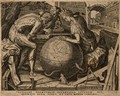
- Pictures
- Online
A woman with a castle on her head traces a compass across a globe while two men crouch over it; representing geometry. Engraving by C. Cort, 1565, after F. Floris, c. 1557.
Floris, Frans, 1519 or 1520-1570.Date: 1565Reference: 25661i- Pictures
Freemasons' symbols, from architectural instruments to cosmic symbols, with an eye looking downward. Etching, 1788.
Date: 1788Reference: 27184i
- Pictures
- Online
A mathematician draws a semi-circle while Minerva watches over him. Engraving by R. Sadeler, 1591, after M. de Vos.
Vos, Maarten de, 1532-1603.Date: 1591Reference: 26097i
- Pictures
- Online
The angel tells Joseph to awaken and take Jesus and Mary to Egypt. Engraving after P. Mignard.
Mignard, Pierre, 1612-1695.Reference: 21792i
- Pictures
- Online
The castle of knowledge, flanked by the spheres of destiny and fortune. Woodcut, 1556.
Date: [1556]Reference: 26090i- Books
- Online
The mariner's compass rectified: containing tables, shewing the true hours of the day, the Sun being upon any Point of the Compass: With the true Time of the Rising and Setting of the Sun and Stars, and the Points of the Compass that the Sun and Stars rise and set with: And Tables of Amplitude. All which Tables are Calculated from the Equinoctial to 60 Degrees of Latitude, &c. With the Description and Use of those Instruments most in Use in the Art of Navigation. Also a Table of the Latitude and Longitude of Places. By Andrew Wakely, Math, Carefully corrected, and very much enlarged with many useful additions. By J. Atkinson, Teacher of the Mathematics.
Wakely, Andrew.Date: 1750- Books
- Online
The line of proportion or numbers, commonly called Gunter's line, made easie: by which may be measured all manner of superficies and solids ; as Board, Glass, Pavement, Timber, Stone, &c. Also, How to perform the same by a Line of Equal Parts, drawn from the Centre of a Two-Foot-Rule. Whereunto is added, The Use of the Line of Proportion Improved: Whereby all manner of Superficies and Solids, may both exactly and speedily be measured, without the help of Pen or Compasses, by Inspection, looking only upon the Ruler. The eighth edition carefully corrected, and other new ways of measuring added. By William Leybourn.
Leybourn, William, 1626-1716.Date: 1715- Books
Compass and rule : architecture as mathematical practice in England, 1500-1750 / Anthony Gerbino and Stephen Johnston ; with a contribution by Gordon Higgott.
Gerbino, Anthony.Date: [2009], ©2009- Pictures
A procession of historical figures accompanying a car on which Time sits measuring the globe; representing the triumph of Time. Engraving by S. Pomarede, 1748, after G. Buti after Bonifacio de' Pitati.
Pitati, Bonifacio de', 1487-1553.Date: 1748Reference: 26230i- Books
- Online
The mariner's compass rectified; containing tables, shewing the true hour of the day, the Sun being upon any Point of the Compass: With the true Time of the Rising and Setting of the Sun and Stars, and the Points of the Compass upon which they rise and set: With Tables of Amplitudes and Declination. Which Tables of Sun-Dials, Semidiurnal Arches and Amplitudes are calculated from the Equator to 60 Degrees of Latitude, either North or South. With A Description of the most useful Instruments in Practice in the Art of Navigation. Also, A Table of the Latitude and Longitude of Places. By Andrew Wakely, Mathematician. Enlarged with many useful additions, by J. Atkinson. The whole revised, corrected, improved and enlarged, with new tables and examples, by John Adams, Teacher of the Mathematics, And Author of the Young Sea Officer's Assistant.
Wakely, Andrew.Date: 1787- Books
- Online
The universal navigator; or, A Comprehensive Treatise of navigation; containing, I. The most useful Problems in Geometry, Measuring of Plank, Timber Bales, Boxes, and Tunnage of Ships. II. Trigonometry with its application to the taking of Heights and Distances, accessible and inaccessible. III. Navigation, (viz.) Plain Sailing, Traverse Sailing, Mercator, Middle Latitude, and Parallel Sailing, with all the several examples wrought Geometrically, Trignometrically, by Logarithms, Arithmetically, by Natural Sines and Tangents, Instrumentally, and by Tables of Latitude and Departure. To which is annexed a curious Collection of Questions to exercise all the above kind of Sailing, with a large and correct Table of Difference of Latitude and Departure, and Meridional parts. Also a Table of Latitude and Longitude of Places. IV. Great Circle Sailing, with a curious Collection of Questions applied thereto, several of which have never appeared in any Treatise of Navigation extant. Oblique Sailing, Turning to Windward, Sailing in Currents, with a Collection of Questions both curious, useful, and entertaining, to exercise the same. V. The Gregorian Calender, shewing the best method of finding the Prime-Epact, Moon's age, time of High Water, with a large Tide-Table, alphabetically digested, the manner of working Observations, the best Method of finding the variation of the Compass. To keep a Sea Journal in the best approved method, both in Merchant's Ships and the Royal Navy, also to correct the Dead Reckoning by a good Observation, by the easiest and best approved Method, illustrated with full, proper, and practical examples of the same, together with all useful Astronomical Tables, viz. the Sun's Declination, a Table of Logarithms, of Nat. and Artificial Sines and Tangents, with a curious collection of Astronomical Problems useful in taking Observations at any time of the Day, or by two Observations, and having the time between them, without regarding the Hour; several of them have not appeared in any other Author. With an appendix, shewing how to work all the cases in navigation by the pen arithmetically, without Books, Tables, or Instruments. By William Chambers, Teacher of the Mathematics.
Chambers, William, teacher of the mathematics.Date: MDCCLXXIV. [1774]- Books
- Online
The mariner's compass rectified: containing tables, shewing the True Hour of the Day, the Sun being upon any Point of the Compass: With the true Time of the Rising and Setting of the Sun and Stars, and the Points of the Compass that the Sun and Stars rise and set with: And Tables of Amplitude. All which Tables are Calculated from the Equinoctial to 60 Degrees of Latitude, &c. with the description and use of those instruments most in use in the art of navigation Also a Table of the Latitude and Longitude of Places. By Andrew Wakely, Math. Carefully corrected, and very much enlarged with many useful Additions. By J. Atkinson, Teacher of the Mathematics.
Wakely, Andrew.Date: 1746- Books
- Online
A treatise of trigonometry, plane and spherical, theoretical and practical. In which the several cases of plane and spherical triangles are solved, instrumentally and arithmetically. As likewise a Treatise of Stereographic and Orthographic Projection of the Sphere. In which the Principles and Theorems on which they depend, are clearly Demonstrated, and the Practice naturally deduced from those Demonstrations. Illustrated in the Stereographic Projection of the several Cases in Right and Oblique Angled, Spherical, Triangles: So that the Requisites may be found without Calculation, by Scale and Compass. To which is added a correct table of logarithms, sines, tangents and secants. By Sam Heynes, late Reader of the Mathematics to His Majesty's Engineers.
Heynes, Sam. (Samuel).Date: 1701- Books
- Online
A treatise of trigonometry, plane and spherical, theoretical and practical. In which the several cases of plane and spherical triangles are solved, instrumentally and arithmetically. As likewise a Treatise of Stereographick and Orthographick Projection of the Sphere. In which the Principles and Theorems on which they depend, are clearly Demonstrated, and the Practice naturally deduced from those Demonstrations. Illustrated in the Stereographick Projection of the several Cases in Right and Oblique Angled, Spherical, Triangles: So that the Requisites may be found without Calculation, by Scale and Compass. The second edition, carefully corrected by the author Sam. Heynes, Teacher of the Mathematicks.
Heynes, Sam. (Samuel).Date: MDCCXVI. [1716]- Books
- Online
Navigation compleated: Being a new method never before attain'd to by any. Whereby the true longitude of any place in the world may be found, whether differing in longitude only, or both in longitude and latitude from any place in the habitable world, by new invented mathematical instruments, viz. The complete navigator, or universal chart. The accute astronomer, compass, admitting of no variation in any latitude, &c. distance-reel and discoverer. By the uses whereof, the certainty of the easting and westing of the globe may be discovered as exactly as the northing and southing already are, and to give at any altitude (having the suns declination, the true latitude, longitude, hour and azimuth all at once by ocular inspection, thereby making the sea barring winds, &c. as direct and plain a path for ships to sail, as the land for travelling. By Francis Cawood, London, student in the mathematicks.
Cawood, Francis.Date: MDCCX. [1710]