1,257 results
- Books
- Online
The seaman's practice: containing a fundamental problem in navigation, experimentally verified: Namely, Touching the Compass of the Earth and Sea, and the Quantity of a Degree in our English Measures. Also An exact Method or Form of keeping a Reckoning or Journal at Sea, in any kind or manner of Sailing. With certain Tables and other Rules used in Navigation. The Latitude of the Principal Places in England: The Variation of the Compass: The finding of the Currents at Sea, and what Allowance is to be given in respect of them. By Richard Norwood, Reader of the Mathematicks.
Norwood, Richard, 1590?-1675.Date: MDCCXII. [1712]- Books
- Online
An epitome of navigation: containing the doctrine of plain and spherical triangles and their Use and Application in Plain Sailing, Mercator's Sailing, and Great Circle Sailing, as also in Astronomy and Geography, and Rules for finding the Variation of the Compass and correcting the Course. Together with tables of the sun and stars Right Ascension and Declination, Of the Latitude and Longitude of Places, Of Meridional Parts. Likewise a Traverse Table, A Perpetual Almanack; and other things very useful in the Art of Navigation. And the logarithm sines and tangents, with the Logarithms of Natural Numbers, from 1 to 10000, according to those exact Tables formerly set forth, by Henry Gellibrand. Carefully corrected and enlarged with many useful additions, by James Atkinson, Teacher of Navigation.
Gellibrand, Henry, 1597-1636.Date: 1701- Books
- Online
An epitome of the art of navigation. Containing the doctrine of plain and spherical triangles, and their Use and Application in Plain Sailing, Mercator's Sailing, and Great Circle Sailing, as also in Astronomy and Geography, and Rules for finding the Variation of the Compass, and correcting the Course. Together with tables of the sun and stars Right Ascension and Declination, Of the Latitude and Longitude of Places, Of Meridional Parts. Likewise a Traverse Table; and other Things very useful in the Art of Navigation. And the logarithm sines and tangents, with the Logarithms of Natural Numbers, from 1 to 10000, according to those exact Tables formerly set forth, by Henry Gellibrand. Corrected and enlarged with many additions, by James Atkinson, Teacher of Navigation.
Gellibrand, Henry, 1597-1636.Date: 1712- Books
- Online
An epitome of the art of navigation. Containing the doctrine of plain and spherical triangles, and their Use and Application in Plain Sailing, Mercator's Sailing, and Great Circle Sailing, as also in Astronomy and Geography, and Rules for finding the Variation of the Compass, and correcting the Course. Together with tables of the sun and stars Right Ascension and Declination, Of the Latitude and Longitude of Places, Of Meridional Parts. Likewise a Traverse Table, A Perpetual Almanack; and other things very useful in the Art of Navigation. And the logarithm sines and tangents, with the Logarithms of Natural Numbers, from 1 to 10000, according to those exact Tables formerly set forth, by Henry Gellibrand. Corrected and enlarged with many additions, by James Atkinson, Teacher of Navigation.
Gellibrand, Henry, 1597-1636.Date: 1706- Books
- Online
The practical navigator, and seaman's new daily assistant. Being an epitome of navigation: including the different methods of working the lunar observations. With Every Particular Requisite for Keeping a Complete Journal at Sea. Likewise The Methods of finding the Latitude by two Altitudes of the Sun; by the Meridian Altitude of the Moon, the Planets, or fixed Stars; and to compute the Altitudes of the Sun, Moon, or Stars, without an Observation. The Manner of Mooring, Unmooring, and Working a Ship in all difficult Cases at Sea. With Directions for conducting her out of Dock, and into the principal Ports and Harbours in the British Channel. Which is The Substance of that Examination, every Candidate for a Commission in the Royal Navy, and Officer in the Honorable East-India Company's Service, must pass through, previous to their being appointed: This, with the Sea Terms, are particularly recommended to the Attention of all young Gentlemen designed for, or belonging to the Sea. To this edition are added, besides many important Improvements, the requisite tables used with the nautical almanac in Determining the Longitude at Sea. The different Methods are exemplified and rendered easy to any common Capacity. Also, a new table, the largest and most correct hitherto published, of the latitudes and longitudes of the principal ports and Headlands in the known World; and all the other Tables useful at Sea. Revised and corrected with such Care that they may be depended on. By John Hamilton Moore, Teacher of Navigation, Hydrographer and Chart-Seller to his Royal Highness the Duke of Clarence.
Moore, John Hamilton, -1807.Date: [1791]- Books
- Online
The description and use of a new sea quadrant, for Taking the Altitude of the Sun from the visible Horizon; Which is so contrived, That the Observer will be liable to no Interruption, or Inaccuracy from the Ship's Motion. And The Latitude at Sea, May be obtained with greater Certainty, and more frequently than by any Instrument of the like Kind hitherto made publick. Invented, Made, and Sold by George Adams, Mathematical Instrument Maker to His Majesty's Office of Ordnance, at Tycho Brahe's Head, the Corner of Racquet Court, in Fleetstreet, London. To which is added, The Description and Use of two Curious Methods for procuring an Artificial Horizon at Sea, To be used with Hadley's Quadrant; one by means of a Whirling Speculum; the other by a Floating Mirrour.
Adams, George, 1709-1772.Date: MDCCXLVIII. [1748]- Books
- Online
The new practical navigator; being an epitome of navigation; containing the different Methods of working the Lunar Observations, and all The requisite Tables used with the Nautical Almanac, in Determining the Latitude and Longitude, and keeping a complete reckoning at Sea: Illustrated by proper Rules and Examples; The whole exemplified in a Journal, kept from England to the Island of Teneriffe: also, The Substance of that Examination, every Candidate for a Commission in the Royal Navy, and Officer in the Honourable East India Company's Service, must pass through, previous to their being appointed: This, with the Sea Terms, are particularly recommended to the Attention of all Young Gentlemen designed for, or belonging to the Sea. So that this Book, and the Nautical Almanac, will be found fully sufficient for the Seaman and Teacher's Use, and is rendered easy to any common Capacity. The thirteenth edition, enlarged, constructed on a new plan, and illustrated with copper-plates. By John Hamilton Moore, Teacher of Navigation, Hydrographer and Chart-Seller to his Royal Highness the Duke of Clarence.
Moore, John Hamilton, -1807.Date: 1798- Books
- Online
The new practical navigator; being an epitome of navigation, Containing The Different Methods Of AtWorking The Lunar Observations, And All The Requisite Tables Used With The Nautical Almanac In Determining The Latitude And Longitude, And Keeping A Complete Reckoning At Sea: Illustrated BY Proper Rules And Examples; The Whole Exemplified In A Journal Kept From England To The Island Of AtTeneriffe: Also, The Substance of that Examination, every Candidate for a Commission in the Royal Navy, and Officer in the Honourable East India Company's Service, must pass through, previous to their being appointed: This, with the Sea Terms, are particularly recommended to the Attention of all Young Gentlemen designed for, or belonging to the Sea. So that This Book, and the Nautical Almanac, will be found fully sufficient for the Seaman and Teacher's Use, and is rendered Easy to any common Capacity. The eleventh edition, constructed on a new plan, and illustrated with copper plates. By John Hamilton Moore, Teacher Of AtNavigation, Hydrographer And Chart-Seller To His Royal Highness The Duke Of AtClarence.
Moore, John Hamilton, -1807.Date: 1795- Books
- Online
A voyage to the South-Seas, in the years 1740-1. Containing, A faithful Narrative of the Loss of his Majesty's Ship the Wager on a desolate Island in the Latitude 47 South, Longitude 81:40 West: With the Proceedings and Conduct of the Officers and Crew, and the Hardships they endured in the said Island for the Space of five Months; their bold Attempt for Liberty, in Coasting the Southern Part of the vast Region of Patagonia; setting out with upwards of Eighty Souls in their Boats; the Loss of the Cutter; their Passage through the Streights of Magellan; an Account of their Manner of living in the Voyage on Seals, Wild Horses, Dogs, &c. and the incredible Hardships they frequently underwent for Want of Food of any Kind; a Description of the several Places where they touch'd in the Streights of Magellan, with an Account of the Inhabitants, &c. and their safe Arrival to the Brazil, after sailing one thousand Leagues in a Long-Boat; their Reception from the Portuguese; an Account of the Disturbances at Rio Grand; their Arrival at Rio Janeiro; their Passage and Usage on Board a Portuguese Ship to Lisbon; and their Return to England. Interspersed with many entertaining and curious Observations, not taken Notice of by Sir John Narborough, or any other Journalist. The whole compiled by persons concerned in the facts related, viz. John Bulkeley and John Cummins, Late Gunner and Carpenter of the Wager.
Bulkeley, John.Date: M.DCC.XLIII. [1743]- Books
- Online
A new sett of maps both of antient and present geography, wherein Not only the Latitude and Longitude of many Places are Corrected, according to the latest Observations; but also the most remarkable Differences of Antient and Present Geography, may be quickly discern'd by a bare Inspection or Comparing of Correspondent Maps; which seems to be the most natural and easy Method to lead Young Students (for whose Use the Work is principally intended) unto a competent Knowledge of the Geographical Science. Together with a Geographical Treatise, in 8-. Particularly adapted to the Use and Design of these Maps. By Edward Wells, M. A. And Student of Christ-Church, Oxon.
Wells, Edward, 1667-1727.Date: MDCCXIV. [1714]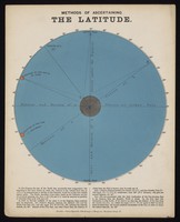
- Pictures
- Online
Astronomy: a diagram showing how to determine latitude. Coloured engraving by J. Emslie, 1851, after himself.
Emslie, John, 1813-1875.Date: 1851Reference: 46555i- Books
- Online
The longitude and latitude found by the inclinatory or dipping needle.
Whiston, William, 1667-1752.Date: 1719]
- Digital Images
- Online
One plate of an astrolabe. The same latitude for 41 degrees.
- Books
- Online
A new and easy method of finding the latitude on sea or land, having two altitudes of the sun and the time elapsed between the two observations, measured by a watch or other time-keeper. By Samuel Dunn, Teacher of Mathematics.
Dunn, Samuel, -1794.Date: MDCCLXXVIII. [1778]- Books
- Online
Observations for determining the length of a degree of latitude in the provinces of Maryland and Pennsylvania, in North America; By Messieurs Charles Mason and Jeremiah Dixon. To which is prefixed an introduction: By the Rev. Nevil Maskelyne, B.D.F.R.S. Astronomer royal.
Mason, Charles, 1728-1786.Date: Printed in the year MDCCLXIX. [1769]- Books
- Online
An introduction to latitude without meridan altitudes; and longitude, at sea; having cotemporary [sic] observations: ... and nautical formulas, engraved on copper plates. By Samuel Dunn; ...
Dunn, Samuel, -1794.Date: 1782- Books
- Online
Tables of difference of latitude and departure: constructed to every quarter of a degree of the quadrant, and continued from one, to the distance of one hundred miles or chains.
Robertson, J. (John), 1712-1776.Date: M,DCC,XCIX. [1799]- Books
- Online
Epitomy of navigation, Containing plain and easy rules, for the working all plain triangles, and their application to plain, traverse, oblique, Mercator and middle latitude sailing; with spherical trigonometry in all its cases, and its application to all the necessary problems in astronomy. To which is added, all necessary tables of the sun's declination, latitude and departure, meridional parts, latitude and longitude of places, &c. Concluding with a compleat table of logarithms, sines, tangents, &c. With the use of all the tables illustrated by examples. First written by Gellibrand, Norwood, and Jones; and now collected and digested into one compendium of navigation.
Gellibrand, Henry, 1597-1636.Date: 1735- Books
- Online
The description and uses of the universal æquinoctial double-ring dial, which serves to find the latitude, hour of the day, sun's altitude, declination, and place in the ecliptick, time of his rising and setting, length of the day and night, and also a most accurate and admirable method for adjusting the latitude in all places, with a scheme curiously engraven, representing the position of the dial in all it's uses; together with so much of the projection of the sphere in the plain of the equator, as is necessary in the question for finding the latitude. Very useful for all travellers and gentlemen, to examine and adjust their pendulum, clocks or watches. Wherunto is added, a well collected table of the latitude of the most eminent place in Europe. Also, a new calculated and correct table of equation. By Gabriel Stokes, mathematical instrument-marker in Essex-Street, Dublin.
Stokes, Gabriel.Date: MDCCXXXI. [1731]- Books
- Online
A method of ascertaining the latitude in the northern hemisphere, by a single altitude of the polar star, at any time; with tables computed for that purpose. By John Stevens, In the Service of the East India Company.
Stevens, John, of the East India Company.Date: 1800- Books
- Online
The description and use of a new and easy formula, for determining the time of the day, the azimuth of the sun, and the latitude ... By Samuel Dunn, ...
Dunn, Samuel, -1794.Date: 1777- Books
- Online
The seaman's complete daily assistant, and new mariner's compass: being an easy method of keeping a journal at sea. Containing rules for working the cases in plane, middle latitude, and Mercator's sailing, by the tables of difference of latitude and departure. The method to find the latitude, longitude, and variation of the compass; how allowances are to be made for Lee-way, variation, heave of the sea, setting of the currents, and to correct the dead reckoning by an observation for a single day or many; with all the tables requisite to be used at sea. The whole exemplified in a journal from the Lizard to the island of St. Mary and every day's work pricked off upon a Mercator's chart. To which is prefixed A short and easy treatise on arithmetic: containing the necessary rules of common arithmetic, decimal fractions, the extraction of the square and cube roots, with their use in measuring all kinds of boards, planks, cases, casks, bales, and packages, usually taken on board. The gauging of casks, and finding a ship's tonnage, worked by figures, gunter's scale and logarithms. Likewise the methods of keeping a ship's accounts, disbursements, the forms of cargo-books, receipts for wages, invoice and manifest of goods, bills of parcels, and letters of credit. The whole rendered so plain, that any person may gain a sufficient knowledge of the above by their own application, without any other assistance. To this edition is added, the use fo Hadley's Quadrat and Mercator's chart, with many valuable improvements. By John Hamilton Moore, teacher of navigation, hydrographer and chart-seller to His Royal Highness the Duke of Clarence.
Moore, John Hamilton, -1807.Date: 1800- Books
- Online
The seaman's complete daily assistant, and new mariner's compass: being an easy method of keeping a journal at sea. Containing [r]ules for working the case in plane, middle latitude, and mercator's sailing, by the table of difference of latitude and departure. The method to find the latitude, longitude, and variation of the compass; how allowances are to be made for Leeway, variation, heave of the sea, setting of the current, and to correct the dead reckening by an observation, for a single day or many; with all the tables requisite to be used at sea. The whole examplified in journal from the Lizard to the Island of St. Mary's, and every day's work pricked off upon a mercator's chart. To which is prefixed A short and easy treatise on arithmetic: containing the necessary rules of common arithmetic, decimal fractions, the extraction of the square and cube roots, with their use in measuring all kinds of boards, planks, cases, casks, bales and packages, usually taken on board. The guaging of casks, and finding a ship's tonnage, worked by figures, Gunter's scale and logarithms. Likewise the methods of keeping a ship's accounts, disbursements, the forms of cargo-books, receipts for wages, invoice and manisest of goods, bills of parcels and letters of credit. The whole rendered so plain, that any person may gain a sufficient knowledge of the above by their own application, without any other assistance. To this edition is added, The use of Hadley's quadrant, and mercator's chart, with many valuable improvements. By John Hamilton Moore, teacher of Navigation, hydrographer and chart-seller to His Royal Highness the Duke of Clarence.
Moore, John Hamilton, -1807.Date: 1792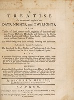
- Books
- Online
A treatise on the various lengths of the days, nights and twilights : with tables of latitude and longitude of the most eminent towns, harbours, headlands, and islands in the world ... / by Richard Mihill.
Mihill, Richard.Date: 1755- Books
- Online
The Vermont almanac, and register, for the year of our Lord 1795, being the third after leap-year, and the nineteenth of the independence of America. Fitted to the latitude and longitude of Rutland, latitude 430 21' north. Longitude 2 [degrees] 9 [minutes] east of Philadelphia.
Date: [1794]