6,041 results
- Digital Images
- Online
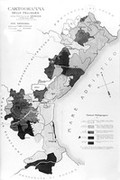
Map: incidence of pellagra in Northwest Italy.

- Digital Images
- Online
Map: incidence of pellagra in Pavia province, Italy.
- Digital Images
- Online
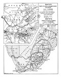
Map of South Africa, showing sites of Bushman drawings.

- Digital Images
- Online
Map Exhibiting the Progress of the Late Epidemic Cholera...

- Digital Images
- Online
Map: incidence of pellagra in Northwest Italy.
- Archives and manuscripts
Map: Rickmansworth and Uxbridge Valley Water Order 1906
Date: 1906Reference: WF/C/P/02/06Part of: Wellcome Foundation Ltd
- Digital Images
- Online
Map of the world in outline, with pacific in centre.

- Digital Images
- Online
Map of the world showing distribution of "Primitive Peoples".
Sonya Rosa Burnstein- Archives and manuscripts
Map of Africa, showing distribution of sleeping sickness
Date: c.1884-1905Reference: RAMC/1242/4/49Part of: Royal Army Medical Corps Muniments Collection- Pictures
Map of British India with four vignettes. Coloured engraving by J. Rapkin, 1851.
Rapkin, J.Date: [1851]Reference: 585748i
- Digital Images
- Online
Map of Xanthus with coloured keys to show origins of various ruins.

- Digital Images
- Online
Map of Lycia by Charles Fellows with coloured annotations showing route taken.

- Digital Images
- Online
Map indicating public and private Sanatoria and Hospitals for the tuberculous sick.

- Pictures
- Online
Map of Ireland, showing Scottish and Welsh coasts. Engraving after J. Speed, 1610.
Speed, John, 1552?-1629.Date: Anno Domini 1610Reference: 576766i- Pictures
Map of the Holy Land in the time of Jesus Christ. Colour lithograph.
Date: 1880Reference: 576749i
- Pictures
- Online
Map of England and Wales and surrounding seas. Engraving by J. Russell, 1803.
Russell, J., active 1803-1804.Date: 31 March 1803Reference: 576760i- Videos
Map of life : science, society and the human genome project.
Date: 1992
- Pictures
- Online
Map of Captain Cook's voyages. Engraving by W. Palmer after Lieutenant H. Roberts, 1785.
Roberts, Henry, 1757-1796.Date: 1785Reference: 566202i- Pictures
Map of the Mediterranean region described in the biblical books of Acts and Epistles. Colour lithograph.
Reference: 576723i
- Digital Images
- Online
Map of St. Albans, Great Britain. In the Public Library, St. Albans via Mr. Gaskell.

- Pictures
- Online
Map of Northern Africa; African people in a rococo frame on the upper right hand of the map. Coloured engraving, 1772.
Anville, Jean Baptiste Bourguignon d', 1697-1782.Date: 1st August 1772Reference: 576757i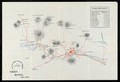
- Digital Images
- Online
Map of Nikko, Japan and its surrounding vicinity, given to visitors staying at the Nikko Hotel
- Archives and manuscripts
Map of Property in the City of Yonkers N.Y. Burroughs Wellcome & Co. USA
Date: 1926Reference: WF/CA/P/07/06Part of: Wellcome Foundation Ltd- Pictures
Map of India for the use of the officers of the army of India. Engraving by J. Dower, 1840.
Dower, John, active 1838-1846?Date: [1880?]Reference: 585572i
- Pictures
- Online
Map of the vale of the Evenlode, Thames, charting stone formation in various colours. Coloured etching by J. Cross.
Cross, John, 1819-1861.Reference: 42448i