193 results filtered with: Maps
- Ephemera
Your guide to University Hospital Lewisham : providing visitors with essential information / Lewisham Healthcare NHS Trust.
Date: [2011?]- Books
- Online
Jefferys's itinerary; or travellers companion, through England, Wales, and part of Scotland, containing all the direct and principal cross roads; with The Addition of every New Road, carefully collected from all the actual Surveys hitherto published. Improved with many thousand names of places more than are in any similar publication. To which are added copious indexes to all the roads and places mentioned in the work, with their exact Distance from London.
Jefferys, Thomas, -1771.Date: MDCCLXXV. [1775]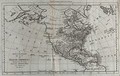
- Pictures
- Online
North and Central America and the Pacific and Atlantic Oceans: map. Engraving, ca. 1777.
Date: [1777?]Reference: 677708i
- Pictures
- Online
Canary Islanders circling a fountain tree (Spathodea campanulata) and filling their urns with the water it secretes. Wood-engraving, ca. 1748.
Date: 1748Reference: 25428i
- Pictures
- Online
Church hospital and grammar school, Ewelme, Oxfordshire: map. Transfer lithograph by J.R. Jobbins, 1858, after F.T. Dollman.
Dollman, Francis T. (Francis Thomas), 1812-1899.Date: May 1858Reference: 17597i- Books
Mappa mundi.
Qiu, Zhijie, 1969-Date: [2019]- Books
Historical atlas of Canada / Geoffrey J. Matthews, cartographer/designer.
Date: 1987- Ephemera
Disability : transport ephemera. Box 3.
- Ephemera
Oversize ephemera. EPH+47.
- Books
An encyclopaedia of North and South America, 1786 / [by D. Fenning and J. Collyer] : with an introduction by G.R. Crone.
Fenning, Daniel.Date: [1976], ©1976- Books
- Online
Historical atlas of England; physical, political, astronomical, civil and ecclesiastical, Biographical, Naval, Parliamentary, and Geographical; Ancient and Modern; from the Deluge to the Present Time in which are Described its Minerals, Curiosities, Inland Fisheries and Navigation, Commerce, Peerages, Noblemen and Gentlemen's Seats, &c. Interspersed with geographical notes and dates for the Curious, and explanations to each map, in order to enable Persons of every Rank to read, with Advantage, the Natural History, Antiquities, Poetry, Belles Lettres, and Geography of this Country. To which are Added, A Physical Map of the Terrestrial Globe, To shew the Connection of the great Chains of Mountains, Seas and Rivers, with those of Britain; and A Political Chart of Europe, To shew the Naval and Commercial Intercourse between this Country and the Continent. Delineated in a Series of Interesting Maps, the Result of a Variety of Critical Researches. By John Andrews, Geographer, Land-Surveyor, Map-Seller, and Engraver.
Andrews, John, 1736-1809.Date: 1797
- Pictures
- Online
American Civil War: the free and slave states, and of the unsettled territory. Wood engraving, 1856.
Date: [1856]Reference: 37933i- Books
- Online
Voyages from Asia to America, For completing the discoveries of the north west coast of America. To which is prefixed. A summary of the voyages made by the Russians on the frozen sea, in search of a north east passage. Serving as an explanation of a map of the Russian discoveries, published by the Academy of Sciences at Petersburgh. Translated from the high dutch of S.Muller, of the Royal Academy of Petersburgh. With the addition of three new maps; 1. A copy of part of the Japanese map of the world. 2. A copy of De Lisle's and Buache's fictitious map. And 3. A large map of Canada, extending to the Pacific Ocean, containing the new discoveries made by the Russians and French. By Thomas Jefferys geographer to His Majesty.
Mueller, Gerard Fridrikh, 1705-1783.Date: 1761- Books
Zirkulare, Sitzungsprotokolle etc. betreffend organisatorische Dispositionen des XVI. Internationalen Physiologen-Kongresses.
International Congress of Physiological Sciences 1938 : Zurich)Date: [1938?]
- Pictures
- Online
The Earth: map. Engraving, 1782.
Date: [1785]Reference: 677709i
- Pictures
- Online
Botanic Gardens, Oxford: plan of the gardens with details of the gateway and greenhouses. Etching, 1707, after D. Loggan.
Loggan, David, 1635-1700?Date: 1707Reference: 21214i- Books
The Peak district / Duphar Laboratories.
Date: 1970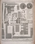
- Pictures
- Online
St Bartholomew's Priory, London: the ground plan, with a key, scale, and depiction of the conventual seals. Engraving by T. Bourne, 1821.
Date: 25 March 1821Reference: 24064i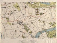
- Pictures
- Online
A map of London: showing sites of medical interest in Chelsea and Kensington. Coloured lithograph, 1913.
Date: 1913Reference: 40394i
- Pictures
- Online
A map of Witwatersrand goldfield, South Africa, showing properties of the Rand Mines Limited. Chromolithograph after Edward H. V. Melvill.
Melvill, Edward H.V (Edward Harker Vintcent), 1859-1914.Date: [1895]Reference: 29630i
- Pictures
- Online
Map of Captain Cook's voyages. Engraving by W. Palmer after Lieutenant H. Roberts, 1785.
Roberts, Henry, 1757-1796.Date: 1785Reference: 566202i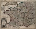
- Pictures
- Online
France: map. Coloured engraving by H. Jaillot, ca. 1710 (?).
Date: [1710?]Reference: 677646i- Books
Yorkshire moors / Duphar Laboratories.
Date: 1971- Books
Beijing li shi yu tu ji = Collection of Beijing historical maps.
Shou du tu shu guan.Date: 2005- Books
The A to Z of Restoration London : (the City of London, 1676) / introductory notes by Ralph Hyde ; index compiled by John Fisher and Roger Cline.
Ogilby, John, 1600-1676.Date: 1992