6 results filtered with: Senex, John, -1740
- Books
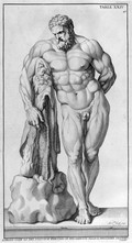
Anatomy improv'd and illustrated with regard to the uses thereof in designing: not only laid down from an examen of the bones and muscles of the human body, but also demonstrated and exemplified from the most celebrated antique statues in Rome. Exhibited in a great number of copper plates, with all the figures in various views / Intended originally for y use of the Royal French Academy of Painting and Sculpture. And carried on under the care and inspection of Charles Errard director of the same in Rome. The dissections made by Doc[to]r Ber[nardin]o Genga ... The explanations and indexes added by ... John Maria Lancissi ... First published at Rome by Dom di Rossi and now reengraven ... And republish'd by John Senex. A work of great use to painters, sculptors, statuaries and all others studious in the noble art of designing.
Errard, Charles, 1606-1689.Date: [1723]- Books
- Online
Atlas maritimus & commercialis; or, A general view of the world, so far as relates to trade and navigation: Describing all the coasts, ports, harbours, and noted rivers, according to the latest discoveries and most exact observations. Together with a large account of the commerce carried on by sea between the several countries of the world, as likewise of all inland trade by means of navigable rivers; the rise, progress, and decay thereof, in its various branches; with methods for farther improvements. To which are added sailing directions for all the known coasts and islands on the globe; with a sett of sea-charts, some laid down after Mercator, but the greater part according to a new globular projection, adapted for measuring distances (as near as possible) by scale and compass, and authorized by letters patent under the great seal of Great-Britain. The use of the projection justified by Dr. Halley. To which are subjoin'd two large hemispheres on the plane of the equinoctial; containing all the stars in the Britannic catalogue: of great use to sailors for finding the latitude in the night.
Date: M.DCC.XXVIII. [1728]- Books
- Online
Proposals for a new sett of correct mapps. By Charles Price and John Senex, geographers to the Queen.
Charles Price and John Senex (Geographers : London, England)Date: 1707]
- Pictures
- Online
Italy: map. Coloured engraving by J. Senex, 1708, after C. Price after John Maxwell.
Date: 1708Reference: 677642i- Books
- Online
A new general atlas, containing a geographical and historical account of all the empires, kingdoms, and other dominions of the world: With the natural history and trade of each country. Taken from the best authors, particularly cluverius, brietius, cellarius, bleau, baudrand, hoffman, moreri, the two sansons, luyts, the atlas historique, Sir John Chardin, Le br un, Tournefort, &c. To which is prefix'd, An introduction to geography, rendring the principal parts of the science easy and containing all that is necessary for the ready understanding of maps. Together with a copious alphabetical index. The maps, which are all engraven or revised by Mr. Sensex, are laid down according to the observations communicated to the English Royal Society, the French Royal Academy of Sciences, and those made by the latest travellers: and the descriptions suited to the course of each map, which has not been observ'd in any other atlas.
Senex, John, -1740.Date: M.DCC.XXI. [1721]- Books
- Online
Miscellanea curiosa : being a collection of some of the principal phenomena in nature, accounted for by the greatest philosophers of this age.
Royal Society (Great Britain)Date: 1705-1707